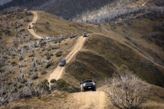
This year we attended the annual Victorian Gathering which is organised on the 4x4earth website and located at O’Toole’s Flat campground in Thomson State Forest. The gathering is largely a social event, however, if you look beyond the gathering there is a multitude of tracks and historic relics to explore.
The nicest part is that some of the best tracks are literally metres from the campground. Flat’s Track, for example, leads directly up the mountain from the campground and is one of the steeper tracks in the area. The track has washouts, ruts and hairpin turns tight enough to test just about any turning circle. Roughly halfway up the track there is a rock feature known to the locals as “The Wall”. As you would expect from the name, The Wall is a series of steep and angled rock steps. There is a bypass track around, but for those brave enough to give it a try it’s a great challenge. A front locker will help immensely here, especially if you are in an IFS vehicle, as lifting a wheel is almost guaranteed.
For images and the full Unsealed experience, CLICK HERE.
Other tracks like Morning Star, Army and S Track are also super steep and great fun, but for something completely different you should give Trig Track a look. A few years ago Trig Track was deemed too steep and was on the verge of being closed due to being marked too dangerous and difficult to maintain. Rather than close it down, Parks decided a better option was to push in a series of switchbacks. The catch was that the switchbacks were so tight that making the turn at either end was near impossible without a multi-point turn. The solution devised was to drive one section then reverse the next. Reversing up a steep hill would have to be one of the most surreal feelings I’ve ever experienced. At the same time you could not wipe the smile off the face of anyone driving this track. This is about the most fun you can have in a vehicle.
Not far from here you can drive across the Thomson Dam wall. A stop here provides one of the greatest views in the area and a chance to observe some magnificent engineering. The dam was constructed in the mid 1970s, completed in 1984 and is the largest water supply reservoir to Melbourne. The dam holds twice the volume of water as Sydney Harbour and more than four times than the next largest water supply to Melbourne.
Continue further south from the dam through Rawson to reach the historic Gold Mining town of Walhalla. At its peak in the 1860’s Walhalla was home to over 4,000 people and although large parts of the town have been preserved, today there are only a handful of permanent residents. A strip of original buildings remain on the main street, the most interesting of these is probably the fire station, which, due to a lack of flat ground, was constructed as a span across the creek. The fire brigade was formed in 1871, however the building was constructed in its current location much later in 1901.
Walhalla has numerous opportunities to explore and soak in some history from a heritage walk to the famous tours of Long Tunnel Extended Gold Mine. While exploring, bear in mind that this town was only accessible by coach or pack horse until 1910 when the railway was constructed. What a life these pioneers led. Guided tours are available to the mine, which includes 8.5km of underground workings that produced 13.69 tonnes of gold up until 1914. In fact, between 1885 and 1908 the mine was one of Australia’s principal gold producers and was Victoria’s top producer for six of those years.
Not to be missed in Walhalla is the Wally Pub. Apart from a cold beer and excellent food, the pub includes walls covered with historical photos. Due to the wealth of Walhalla during the gold mining period, a permanent photographic studio existed in the town. The pictures are all over the place if you look hard enough.
Heading back to camp, we chose an alternate route rather than going back over the dam. This route passes by on the low side of the dam, along Beardmore’s Track. Here there is a gorgeous crossing of Thomson River, followed by a climb up to Walhalla Road that takes in views of the low side of the dam.
First thing the next morning we were off to check out the amazing views on offer at over 1400m above sea level from Mount Useful. The quickest way from camp, at around 450m above sea level, is straight up White Star Track, which begins with a shallow crossing of Donnelly Creek, followed immediately by a steep climb up, which finishes at over 1000m elevation. A short drive along the good condition McEvoy’s Track takes you to the turn off to Mt Useful. Once on top, the stunning views stretch way over the top of O’Toole’s all the way back to Thomson Dam. Camping up here is possible but only for the brave, as nights would be extremely chilly. There is a drop toilet here, but I strongly advise against using or even looking at this one. It is best described as full. Time to make the descent back down to camp, and this time we chose Willoughby Spur Track. This track is even steeper than White Star and includes some rutted out sections. At the bottom of the track you once again cross Donnelley Creek and this time there is a small car park. If you’re in the mood for a walk there is a short walk here via a large water wheel to some mining relics, including a crusher and large boiler.
Back to camp and it was time for my favourite part of the trip: Grumpy’s Historic Tour. First stop was Jorgenson’s Hut, which is another success story for the four-wheel-drive community. The hut was one of four lost in the 2013 bushfires. It has since been rebuilt with the help of volunteers and bollards have been installed to provide a barrier around the hut.
Further along our tour was Toombon Mine. Toombon itself was a small township that included a hotel, school and post office. At this location all that remains are some degraded relics, a chimney stack and a deep mine shaft. The shaft is covered with wire mesh, however care should still be taken here – it’s a very long way down. In fact, the shaft reached a maximum depth of 195m during its operation.
Not far from the mine relics lies a private property that is actually the site of the former Toombon Hotel (The Wayside Inn). The site included the former inn, horse stables and a morgue. At this stage access is restricted, but stay tuned as work is being done to return public access to the area. Looking down on the site from the road you can see the original footings of the hotel.
A little further down Toombon Road, just past the intersection of Donnelly Creek Road, lies Toombon Cemetery. Unfortunately almost all records of the cemetery were lost in bushfires, however recent restoration works have been undertaken to re-mark the graves. It’s a touching tribute to the tough times that existed during the gold rush of the late 1800’s and early 1900’s. Keep an extra eye out for a group of marked graves – this is believed to be a family of Chinese miners.
Code’s Flat, located further down Donnelly Creek Road, is a privately owned area where people can rent a cabin right by the Aberfeldy River. The Code family occupied this property for over 50 years. Part of the property includes a shed full of historical monuments. Look up Code’s Flat on Facebook and try to arrange access. A gold coin donation is all it costs for a look and believe me, it’s well worth the price of admission. Apart from small pieces of history lying about the shed like ham radios and old push bikes, there is probably the best-conserved crusher in all of the High Country. Everything on it still works; in fact, it’s in such good condition that the wheel can be turned by finger pressure alone.
Back out to Walhalla Road and we visited the grave of a local celebrity of a different kind. Kitty Kane was a lady of the night who was popular along the route between Walhalla and Wood’s Point. When she died the miners decided to give her a grand send off, however excessive alcohol consumption presented a problem for the miners, and Kitty’s 22 stone weight presented a problem for the pack horses. As a result, she never made it to her intended destination of Aberfeldy Cemetery and was laid to rest by the road, not far from her shanty.
Not far from Kitty’s Grave we were again greeted with majestic views across Thomson Dam from Cast Iron Point. As mining operations in the area ceased, much of the scrap metal was collected for recycling at this location… nothing like a dump with a view I guess.
The day ended back at camp with the annual duck race. Participants buy a numbered rubber duck and hundreds are floated down Donnelly Creek. Prizes are given to the victors and this is immediately followed by the drawing of the raffle. Prizes are both won and auctioned off with all proceeds going to charity. These Victorian meets have made over $3,500 for various charities over the eight years they have been running.
A communal fire and a few drinks was the perfect end to a magical weekend camped at O’Toole’s Flat. Not only should we appreciate that we live in a country where places like this exist, we should also feel privileged to have these areas maintained and improved by like-minded four-wheel-drive enthusiasts. If the efforts put in to maintain tracks and campgrounds in this area are not inspiring then I’m not sure what is. Once again, congratulations to everyone involved. Keep up the good work.
Words and Photography by Todd Hore


