Drop in on the way to The Cape – A kettle full of gold could be yours!
The Cape is a long way north of everywhere so you’ll need to stop somewhere on the way there. Wongi Waterholes is a few kilometres north of Maryborough and only a few kays off the Pacific Highway. Even though it seems close to town, it feels a long way from anywhere.
There is a great swimming hole at the camp. The aboriginal word ‘Wongi’ is said to mean ‘deep water’. I didn’t dip my toes when I visited, as the waterhole was flooded. So I reckon it was very deep water. The waterholes were used by the Indigenous population as they travelled inland from the coast and Fraser Island.
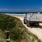
Even after a lot of rain, the access to camp was easy with plenty of flat ground for a single vehicle or a group – although you do need to cross a long causeway just before camp. If you’ve got a kayak, a paddle along the waterholes would be a good way to relax after a long drive.
More than a waterhole
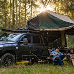
Even if you’re not heading as far as The Cape, Wongi is a great place to spend a weekend or a few days. The State Forests surrounding the waterholes are filled with plenty of 4WD trails to explore. I was able to find some interesting tracks, a hill with a view and a town with a legend of lost gold as I took the FJ out on the tracks.
I was keen to find a log bridge that I had seen in photos of the area. Too easy, it was only about 6km west of the campground. The bridge is likely to date back to the 1860s when timber harvesting was a big industry. Much of the State Forest has been replanted with pine, so keep an eye out for logging trucks.
The next point I was searching for on the map was the old Cobb & Co coach road. As I headed west along the Kellogum forestry road which was well graded, I was surprised to find a deep water rut cutting through the road. This would have been dangerous if hit at speed, and more than likely do some serious damage to the suspension. Not far from here, I turned left onto a much less travelled track. It was heading in the right direction towards Mt Doongul and it showed on my Hema map – so I figured it was good to go.
This section of the track runs through State Forest which also has a current grazing lease – so keep an eye out for the Brahman cattle close to the roadside. It was along here that I spotted a bathtub with a roof in the middle of a cleared area. Was this a relic of the 1900s or a hermit’s quest for cleanliness?
After closer inspection, it was revealed that it was a salt lick for the cattle. There was thick, green grass surrounding the lick where only a few weeks earlier the place had been a dustbowl after months of drought. The farmers who told me this looked at me as if I was from another planet in my yellow FJ with its orange trailer. I’m used to that.
The NBT and Cobb & Co Track
The narrow track crossed a powerline track a couple of times before intersecting the National Bicentennial Trail (NBT) which links Cooktown in Queensland to Healesville in Victoria. If you’re keen you can walk, cycle or horse ride the full 5,330 kilometres. At this point the NBT follows the old Cobb & Co Track that ran between Maryborough and Gayndah. These days it doesn’t get a lot of use, so expect a bit of pinstriping.
A short detour off the NBT took me to the summit of Mt Doongul. From here you can get some great views in all directions. The low cloud and drizzle limited my view somewhat but it was definitely worth taking the track to the top. From here, the track narrowed further; there were some small creeks and muddy sections before reaching the gate at Musket Flat.
Near the gate was an original signpost from the Cobb & Co era pointing the way. The termites have almost won so I’m not sure how much longer it will stay standing. After passing through the gate, there’s a shelter with images of past residents of Musket Flat. In its day it held horse races and had at least one hotel; and the blacksmith employed 20 people.
It’s all in the name
The name of Musket Flat was given to the area after a bullock team was camped by the creek in the 1850s. A couple of inquisitive Indigenous folk were checking out the yokes and other equipment around the dray when one picked up the ringed musket (old rifle). The bullock drivers spotted him and chased him off. In the ensuing pursuit, the musket was tossed into a waterhole and never recovered.
Despite the official name of the town being changed to ‘Elliot’ after a local politician in 1864, the name Musket Flat persists today with the locals. Musket Flat was also known as a great place for teamsters to stay drunk for up to three months at a time. One such character was Mr Big Jim who ‘had a violent antipathy to work’ and set up an illegal still to make a bit of extra cash.
A kettle of gold
When the local police shut down Big Jim’s still, he went bushranging. Eventually the police apprehended him at the local pub. As he was removed, he spoke: “Boys, I know I am done for… there is a kettle full of sovereigns… you may as well have it. The police will never find it.” A little later her gave further details. “Look for a high rock, and a rock bridge across a creek… search there for a cave. So long.” Whether it was a tall story or if anyone has actually found the kettle of gold is unknown to this day.
If you are looking for a lovely spot to rest, or to find treasure, Wongi Waterholes could be the place for you.