Advertisement
LIVE DISASTER RECOVERY UPDATE (17 Jan, 2026): Victoria remains in a State of Disaster as back-to-back emergencies collide. While destructive flash floods have shattered the Surf Coast, the Wonnangatta – Dargo complex fires are still under a ‘Watch and Act’ alert. The Great Ocean Road is CLOSED between Lorne and Skenes Creek due to landslips and structural damage at the Cumberland River Bridge. Do not enter the Alpine or Surf Coast regions.
If you’re out on the tracks in Victoria, nature has just delivered a brutal one-two punch. While fire crews continue to battle significant blazes in the Alpine National Park, the Surf Coast is reeling from a “rain bomb” that dumped a record-breaking 186mm of rain at Mount Cowley west of Lorne. At its peak, 115mm fell in a single hour—nearly 10% of the region’s annual average in one afternoon. The situation has pivoted from a fire emergency to a massive recovery operation, with rescue teams winching hikers to safety and geotech crews assessing structural sinkholes on the Great Ocean Road.
Nature’s whiplash: ‘Rain bomb’ triggers coastal devastation
The 2026 Victorian fires are still active, but on the coast, the threat is now structural. The massive storm cell triggered flash flooding so severe it pushed the Cumberland River Caravan Park’s main residence off its stumps and smashed vehicles against bridge pylons. The volume of water surged with enough force to sweep between 10 and 20 cars and multiple caravans into the Bass Strait.
Look, the reality is that the tracks aren’t just muddy—they are being washed away. Even high-clearance rigs are being taken by currents at river mouths. If you’re near Wye River or Cumberland River, you need to follow SES directions and stay clear of the bridges, which are currently being cleared of debris and smashed vehicles.

Alpine Alert: Wonnangatta fires remain active
Don’t let the coastal rain fool you into a false sense of security. Inland, the rain has been minimal, and the risk remains extreme. A ‘Watch and Act’ remains in place for the Wonnangatta – Dargo Complex fires, where crews are battling flare-ups caused by gusty winds. Critical 4WD territory, including the Wonnangatta Valley, Talbotville, and Eaglevale, is strictly off-limits to ensure no campers are trapped by erratic fire spread.
| Region | Status (17 Jan) | Technical Warning |
|---|---|---|
| South West (Surf Coast) | Flood Recovery | GOR closed; record 115mm/hr rain bomb. |
| Alpine (Wonnangatta) | Active Fire | Watch & Act; Alpine National Park south of Dargo closed. |
| Mallee / Wimmera | Parks Closed | Little Desert and Wyperfeld remain closed due to fire risk. |
| North Central | Infrastructure Risk | V/Line suspended on Bendigo/Swan Hill lines. |
Infrastructure Alert: Bridge sinkholes and landslips
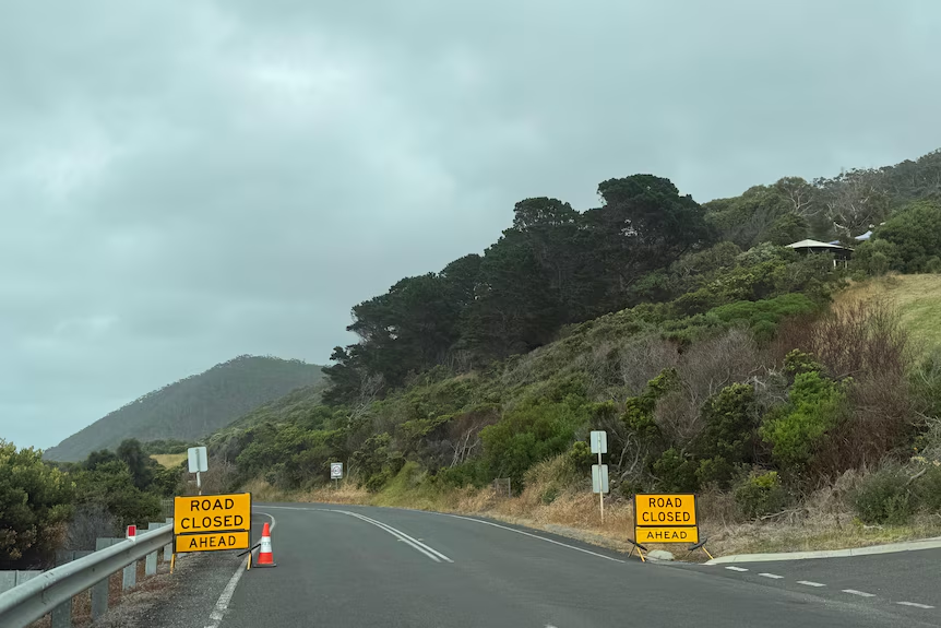
The Great Ocean Road remains closed between Fairhaven and Skenes Creek. Beyond the flood debris, geotech teams are dealing with landslips and structural concerns at the Cumberland River Bridge. This means even once the water recedes, heavy vehicles and 4WDs will not be able to cross until structural integrity is confirmed.
In the north, the rail network is still in pieces. The Bendigo and Swan Hill lines are out of action, and freight traffic is being diverted, adding more pressure to the Princes Highway. If you’re towing, keep your eyes on the road and your dash—stop-start traffic in these conditions is a cooling system’s nightmare.
⚠️ CAUTION: Do not attempt to cross any bridge in the South West until it has been officially cleared by VicRoads. Floodwaters have undermined road foundations and riverbanks across the Otways.
The risk has shifted, but hasn’t left
The 2026 Victorian emergency is a different beast today than it was a week ago. We’ve gone from catastrophic heat to record-breaking floods, and the danger to 4WDers is higher than ever. Whether it’s a fire front in the High Country or a sinkhole on the coast, the tracks are currently a liability. Follow the directions of the SES and CFA, get to the relief centres if you’re displaced, and let’s wait for the geotech and fire crews to do their jobs.
Read next
How to prepare your 4WD for bushfire season
Safety gear you’d regret leaving behind
Advertisement