Spotlight on Murray-Sunset National Park
Glenn Marshall explores Victoria’s remote Murray-Sunset National Park by 4WD, discovering challenging sand driving and top camping spots.
Published on: 26 April 2025
Advertisement
Glenn Marshall explores Victoria’s remote Murray-Sunset National Park by 4WD, discovering challenging sand driving and top camping spots.
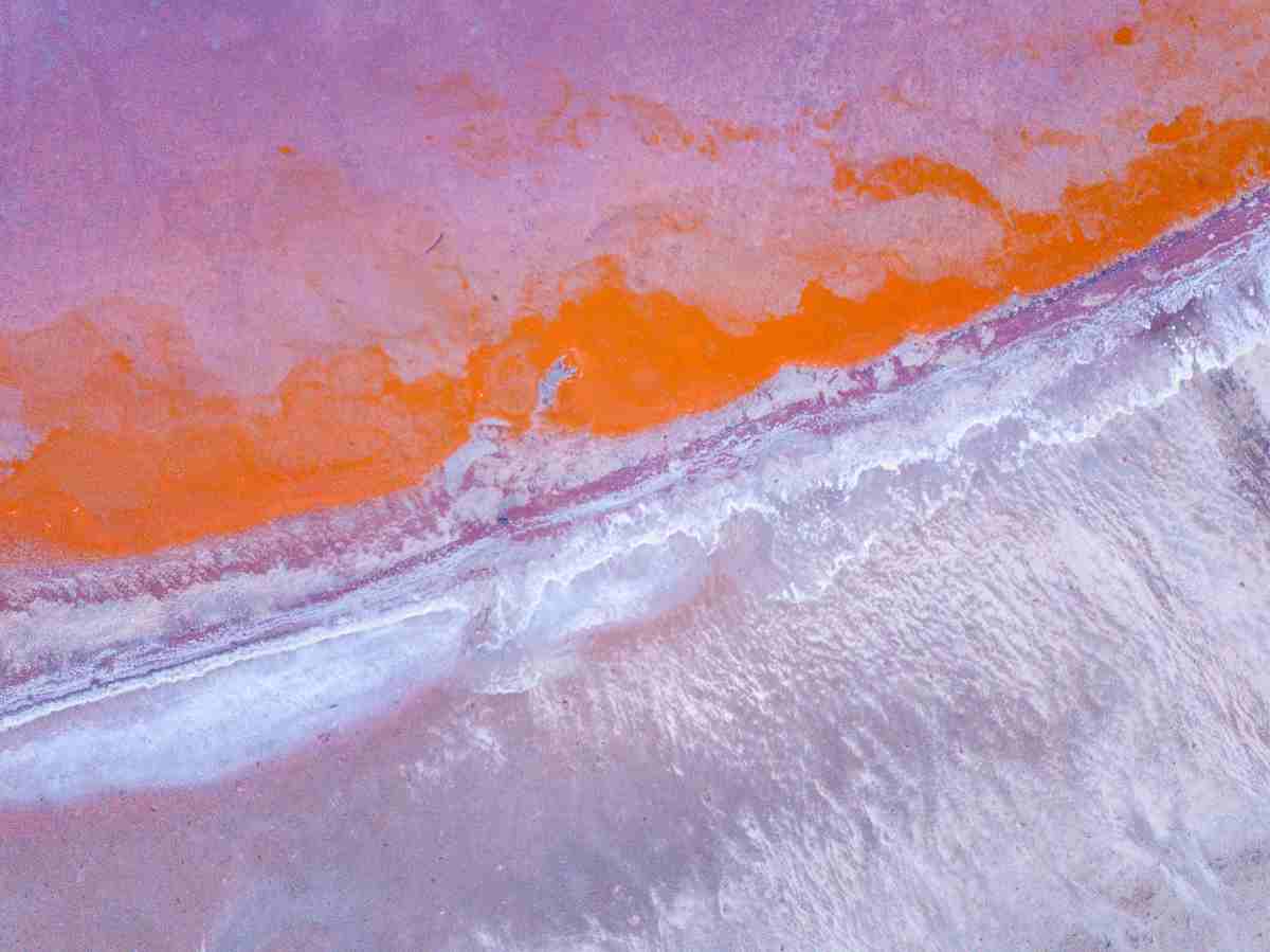
Any man (minus his dog) can get to the Pink Lakes and freak out at the red algae doing its thing and some rusty, old salt-mining relics. But there is much more to see if you have a 4WD with high clearance, a good set of tyres and a thirst for challenging sand driving. Pack your compressor, track mats, tyre gauge and the thrill of adventure, the real Murray-Sunset National Park will give you the ride of your life.
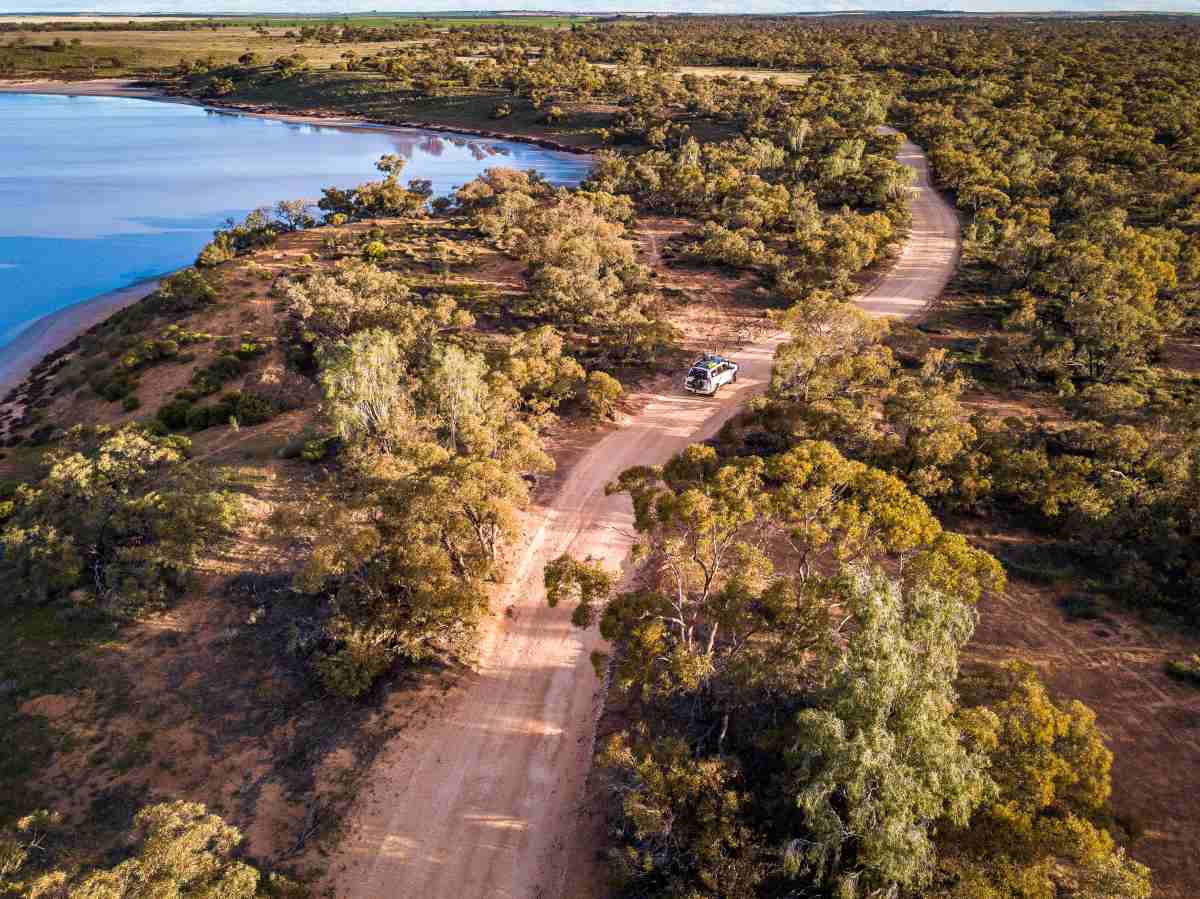
You can access Murray-Sunset National Park via the Pink Lakes Road, then jump onto Pioneer Drive, which leads you to the real stuff. Let’s start with Grub Track, great name, even better track. Drop some air out of your tyres as this is the first of many awesome tracks. I followed the Grub Track a few kilometres until I reached the junction with the Clay Lake Track.
Not having explored this track before, I was keen to check out Red Lake. I was glad I did, as the old fence posts and several other pink lakes along the way were breathtaking. Red Lake was, in fact, pink, and it was nice to sit high on the sand dune and watch the shades change as the sun played hide-and-seek.
Returning along Clay Lake Track, I took Honeymoon Hut Track to Mt. Crozier Track. Mount Crozier was my next destination, and not much of a mountain at a mere 90m above sea level. However, it is a gut-busting, quad-burning climb to the top. The views across the park are amazing. The camping area at Mt. Crozier is spacious, with fire pits and tables spread about. A clean drop toilet tops it off.
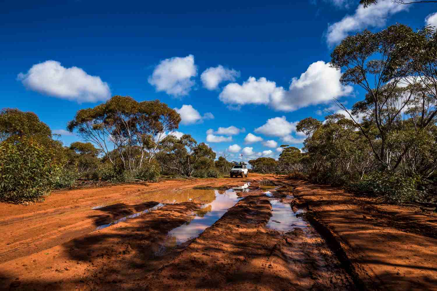
On the Mopoke Track, I was stopped by a couple of feral kids playing in the sand. No, they weren’t human. The track thinned as I drove through a pocket of mulga and Cypress Pines. I was the sole person at Mopoke Hut, where the effects of the previous week’s downpours were still evident, with patches of water occupying the low-lying areas of the track. The recent rains had also flattened most of the tracks, making the sand driving very easy.
Mopoke Hut was constructed in 1962 by Bill Henschke as somewhere to rest after driving a herd of his cattle on horseback from his ‘Yaramba’ property, or mustering and yarding overnight to drive back home. To save having to carry sleeping and cooking gear, he built the hut. Bill relinquished his grazing licence to the Government in February 1990, stipulating that the hut remains as a place for travellers to stay at Murray-Sunset National Park. Unfortunately, the hut was badly vandalised in 1991 but was thankfully rebuilt by the Mildura 4×4 Club.
It was a bloody cold night, and I awoke to a light covering of frost. I moved slowly and allowed the sun to work its magic; there wasn’t a cloud in the sky. On leaving the hut, I met up with the ranger and stopped for a chin wag. The rain had produced growth everywhere, and the tracks had been impacted. His wish was that idiots stay out of the water on the track and take the diversion tracks; “there is no money to grade these tracks.” Look after them and they will remain open. Simple.
The 10-kilometre southern section of the Rocket Lake Track was slow going. Usually it’s due to the deep, soft sand, but this time it was the amount of water lying on the track in the swales between the dunes. The sand driving was the easy part. Rocket Lake was named by the workers on the rail line because the bosses sent up a rocket to signal when it was break time. These days, it’s a wide-open expanse that hasn’t seen water in many years. The camping here is also good, with the usual facilities in the park. A campground with different facilities is at the Shearers Hut, and it was there that I headed next.
I was the sole camper and decided to set myself up for a few days. The difference between the other campgrounds within Murray-Sunset National Park is the accommodation options. You can bush camp as per normal, or if you have a large group, book one of the hostel-style rooms online or through Parks Victoria. If you take this option, you also get a kitchen, a flushing toilet, and a hot shower. I like camping here as you have access to some great tracks, you can occasionally get mobile reception (especially on a clear night), and the birdlife is plentiful.
On checking the map, the Border Track grabbed my attention. As a mere male, following a track down a border is something that must be done, no matter what. While not as challenging as the famed section further south, this section is still a great drive. There are still some large sand dunes to tackle, but they aren’t as gnarly as their southern cousins.
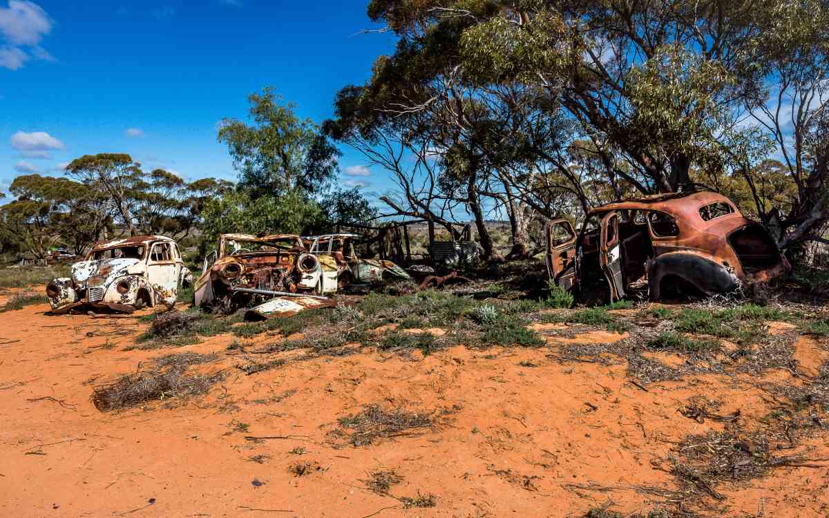
From the Shearers Quarters, I took Taparoo Track up to the Stuart Highway. It was a beautiful drive, especially across the Copi Plains. The emus and kangaroos were plentiful, and the sheep loved it too when they roamed this district. I stumbled across the old ‘Taparoo’ Homestead site. The display of old cars was amazing, and yet so out of place. On reaching the blacktop, I headed towards South Australia, taking the opportunity to put my rubbish in one of the bins before turning south onto the Border Track.
When the track reached Settlement Road, it changed dramatically. It was slow going as the sand deepened and the moguls appeared. Between first and second gear, dodging low branches, twisting and turning, riding out the bumps. The bush really closed in, and the dunes became more frequent. The next 14 kilometres took me nearly two hours, and when I reached Pheenys Track, it was time to abandon the border and head back to camp.
Pheenys was a doddle, smooth and wide before turning onto the Millewa South Bore Track that took me back to the Shearers Quarters. This track was severely corrugated in patches and followed an old fence line from days long gone. The bush was tightly packed, and it wasn’t until I neared the Shearers Quarters that the land opened up again into prime sheep grazing land. The wind picked up as I prepared a fire; the sound of it moving through the trees was intoxicating. Too bad I was the only one here to enjoy it.
To exit Murray-Sunset National Park, I jumped back onto Pheenys Track, which was good going until a 20-kilometre stretch between Bambil South and Underbool Tracks. There were numerous water-damaged sections that required diversions, but a couple offered no option but to drive through. Picking the right line was a must. Underbool Track was sandy with many dunes within a short section before I turned onto Nowingi Line. This was straight, flat and easy once the right speed was reached to negate the corrugations. An old gypsum hopper was the final highlight before I finally reached the Calder Highway and the end of my trip.
Words and images by Glenn Marshall
There are a number of campgrounds within Murray-Sunset National Park, and many of the 4×4 tracks lead to picturesque shady sites along creeks. Camping is free, and no bookings are required. However, all campers must be self-sufficient as no drinking water or rubbish bins are provided. Those needing a break from their tent will find bookable accommodation at the Shearers Quarters.
| Campground | 4WD/2WD | Toilets | Picnic tables | Fire pits | Notes |
|---|---|---|---|---|---|
| Border | 4WD | No | Yes | No | |
| Henschke Track | 4WD | No | Yes | No | |
| Lake Becking | 2WD | Yes | Yes | Yes | |
| Lake Crosby/Main Campground | 2WD | Yes | Yes | Yes | |
| Mopoke Hut | 4WD | Yes | Yes | Yes | |
| Mt Crozier | 4WD | Yes | Yes | Yes | |
| Mt Crozier Remote | 4WD | No | Yes | Yes | |
| Pheenys Track | 4WD | Yes | Yes | Yes | |
| Rocket Lake | 4WD | Yes | Yes | Yes | |
| Shearers’ Quarters | 4WD | Yes | Yes | Yes | Bookable accommodation can be found here |
| Wallpolla Island | 4WD | Accessible by 2WD in dry weather. Gates will be closed during flooding. | |||
| Lindsay Island | 4WD | Accessible by 2WD in dry weather. Gates will be closed during flooding. |
A compressor and tyre gauge, a tyre repair kit, firewood, food and water. Take out what you take in (except wood, of course). Also, make sure you have a hard-copy map of Victoria’s deserts – mobile reception is sketchy at best.
Murray-Sunset National Park is located 550 kilometres from Melbourne and 400 kilometres from Adelaide. Mildura and Renmark are the largest towns nearby and have all the facilities you need.
The cooler months from April to September are the best times, but access may close after rain. The warmer months bring swarms of native bees that are attracted to water.
Once you move away from the Pink Lakes, most tracks will offer you a good challenge in the deep sand. When it is warmer, the tracks are even more challenging.
This article contains affiliate links to products. We may receive a commission for purchases made through these links.