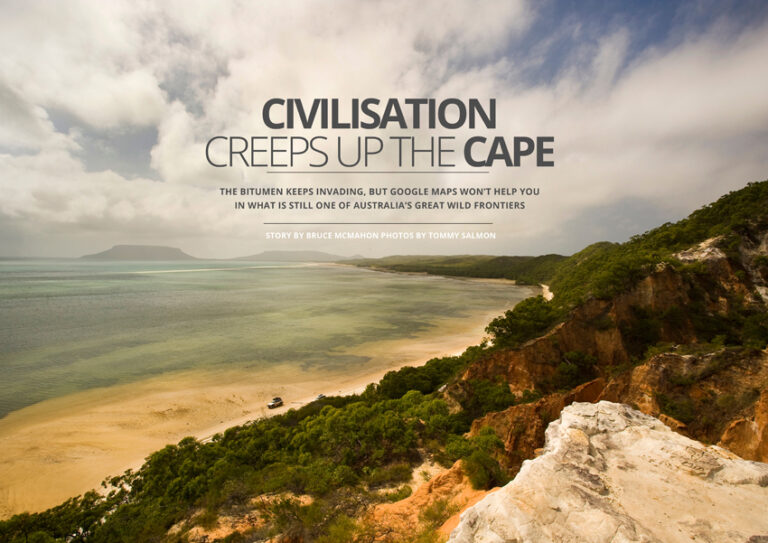
First seen by Europeans as far back as the 1600s, it remains one of white man’s last frontiers. It’s been a place of big adventure, big mines and big cattle properties. But times are changing as civilisation – and the bitumen – heads further north. Today the track to the Tip remains a robust outing for four-wheel drivers and fisherfolk, well-travelled by many and well-mapped by the likes of Hema. Try for Google directions for those 1000-odd kilometres from Cairns to the top and comes the reply: “Sorry, your search appears to be outside our current coverage area for driving.” This 150,000 square kilometre peninsula, home to less than 20,000 people, is no place for 24/7 internet access. It is no place for the ill-prepared or ill-informed. What it offers is a range of Australian beauty from open scrublands to rainforest-lined beaches and all manner of wildlife. Plus the sense of accomplishment you get from standing on the top of the country. Today, off that rough, often rugged and flooded track, there’s also ancient culture, conflicts and changing times. The original inhabitants up this way were some 42 tribes, each with their own language and culture. It’s said the word kangaroo comes from the local Guugu Yimithirr people’s word gangaroo, picked up by Captain Cook and crew while the Endeavour was repaired at Cooktown in 1770. There were early skirmishes between black and white as Europeans moved in, bringing telegraph lines, missions and cattle. A Special Commissioner to the Aborigines in 1895 noted: “Considering the shameful manner in which the aboriginals had been treated over a large area of the peninsula, their forbearance was amazing.” Much history and culture remains with around 70 per cent of Cape York Peninsula’s population indigenous. Many of those original languages are gone, but customs such as Lockhart River art, Arukun basket work and the biennial Laura Dance Festival remain. In the early 20th century many Aboriginal people were shifted into missions and reserves, but these areas were often redrawn again in the name of development, such as the discovery of bauxite at Weipa in 1955. There have been ongoing battles to protect traditional lands from ‘progress’, such as a proposed space port, mooted in the late 1980s. Some of those fights to preserve the peninsula’s wilderness and history have been led by whites. One of the most famous was the 1983-1984 protest and blockade to stop, unsuccessfully, the Cape Tribulation to Bloomfield Road, headed from the Daintree to Cooktown. More than 20 years later it appeared mining applications threatened 12,300ha of wetlands in the Steve Irwin Reserve on the western cape. After the Crocodile Hunter’s death in 2006, the Australian government helped buy 135,000ha as a reserve in his honour, and when mining threatened those wetlands, Save Steve’s Place became a nationwide campaign to preserve the area. In late 2013 the Queensland government announced the Irwin reserve and the Wenlock River – “a strategic environmental area” – would be protected from open-cut and strip mining. While this move upset bauxite miners, Deputy Premier Jeff Seeney claimed that scrapping the previous government’s Wenlock, Archer, Stewart and Lockhart Basin Wild River declarations would better safeguard the region’s biodiversity while also opening up other opportunities. This announcement coincided with the release of the state’s draft Cape York Regional Plan, designed to foster development and economic growth in the region. Here the state sees potential for more mining and more tourism, both helping address what’s seen as “the economic disadvantage in Cape York, especially in the Indigenous communities”. Seeney says: “We are intent on making every effort to make sure that there is some sort of a normalised economy in Cape York that provides Indigenous communities with an opportunity for jobs … for home ownership … for hope and economic growth.” It wants to improve the region’s economic development and diversity while protecting environmental value and reducing “potential land use conflict” to help attract investment in the area. The plan, to be finalised in late 2014, divides Cape York Peninsula into environmental areas where development is limited and general use areas open to grazing and mining. But traditional owners and conservationists claim the draft does not protect pristine areas of wilderness from development, nor guard important cultural sites such as rock art galleries at Laura, believed to be up to 30,000 years old. Some pastoralists believe their properties may be compromised and there have been complaints too of a lack of consultation from some quarters. More than 6000 Australians made submissions on the strategy, many with guidance from the Australian Conservation Foundation’s website. The ACF believes the plan does not provide meaningful protection and leaves most of Cape York’s iconic landscapes vulnerable to mining and other forms of development. Regional Development Australia’s Far North executive officer Sonja Johnson believes Cape York communities understand it’s useful to have a regional plan. But many would like a more community-led plan, an aspirational plan, one not just concerned with land use but also a vision for the economic and social future of the peninsula. Meanwhile there’s $210 million promised in federal funding to help seal the Peninsula Developmental Road the 560km from Lakeland to Weipa. Many Cape Yorkers would welcome more bitumen and bridges, helping transport across the region and making the area more accessible to more tourists. Now that there’s bitumen into Cooktown, tourist numbers have grown to the point where the little tropical settlement now has peak and off-peak seasons. Johnson says an all-weather surface on the PDR – the Cape’s main artery – would bring economic and social benefits, not only to the peninsula but also the Torres Strait, an area that’s a key component in northern development. A sealed road would also aid tourism, allowing more conventional travellers greater access to the far-flung north. But, she said, there would long remain tracks and byways and fishing spots on Cape York Peninsula accessible only by four-wheel drives. Sealing that main road would not destroy any of the cape’s natural beauty and wonders. Cape York Sustainable Futures chief executive Trish Butler says it’s time locals had access to some basic rights and needs, such as all-weather roads, that other Australians take for granted. It was most often outsiders, she said, who opposed development opportunities for people such as the Cape’s farmers. Some may argue a strip of bitumen to the Tip, however narrow, may diminish the testing character of one of our last frontiers. Maybe it’s time to get off that beaten track and discover the beauty and culture of Cape York often overlooked on the side tracks. Cape crusaders Two of the region’s great champions don’t despair about change, writes Dan Lewis Cape York the moons Is it really possible to make the epic 4X4 pilgrimage to Cape York so many times you lose count of the number of visits? If you are Ron and Viv Moon it is. Last year the veteran travellers made what they think was their 37th trip to the Cape. Yet the region is so vast and wild they still managed to visit places they hadn’t experienced before. Twenty-eight years ago the Moons published their first Cape York – Travel & Adventure Guide and this year they have brought out the 13th edition of what is an invaluable tool for anybody looking to visit one of Australia’s great bush frontiers. It’s also available as an ebook. But even the Moons confess they can’t keep up with the evolution of the Cape. A prominent disclaimer at the opening of their latest publication says: “Cape York is changing. Roads are improving, mining companies are opening up new areas and Government departments (National Parks etc) are continually upgrading their facilities. Aboriginal communities are opening their doors to travellers, while asserting more control over their lands. If you find things different to what we say, please don’t blame us – well not too much anyway! We would really appreciate an email, Facebook message or quick note on what you found.” With the bitumen continuing to expand, many pastoral leases being transferred to national parks and traditional owners, and the mining industry booming, some may mourn that the Cape is losing its wild ways. The Moons, however, remain upbeat. “The times are changing, but even so the vast majority of the Cape remains untouched,” they write. “In many ways the Cape is better now than it was in the past, as cattle properties and Aboriginal communities have opened their doors to tourism and passing travellers. “While many will consider much of the adventure lost as time and change continue, it should be remembered that the Cape is a big place. Rivers still remain unpaddled, spectacular expanses of pristine forest remain untouched and stretches of beach untrodden. “Take your time – sample the beauty and experience the delights and the adventure that the Cape can offer.”
Read more ->